Office 33 MoNRE Government of Vietnam
From 2009 – To 2009
Completed Successfully
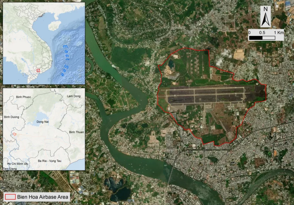
Dioxin (2,3,7,8- tetrachlorodibenzo para dioxin or TCDD) contamination in Vietnam originated from the armed conflict in the 1960s and 1970s when herbicides were used to defoliate terrestrial forests and mangroves, and clear the perimeters of military installations and to destroy crops. The main chemical used was Agent Orange, which contains trace levels of dioxin. Several areas of storage and loading of Agent Orange have continued to have dangerous levels of dioxin in the soils. Bien Hoa military airbase is one of three dioxin contaminated hotspots that have been identified in Vietnam.
The Office of National Steering Committee 33 (Office 33) of the Ministry of Natural Resources and Environment (MoNRE) contracted DSI, LLC (DSI) to conduct the “Preliminary Contaminant Transport Study of Dioxin in and Around Bien Hoa Dioxin Contaminated Hotspots.” The specific objective of this assignment was to assess the spreading of dioxin in the Bien Hoa Hotspot through surface water runoff and run-on with the use of comprehensive hydrologic and hydrodynamic models.
Bien Hoa Airbase area map.
The key points of the project included assembling and conducting an initial assess- ment of the contaminant data and other existing environmental data impacting dioxin fate and transport; conducting a field survey of the hydraulic structures and major runoff control features of Bien Hoa airbase; measuring the bathymetry and thick- nesses of sediment to determine the volume of contaminated sediments in impacted ponds; analyzing the topographic data for the airbase and surrounding areas to determine watershed and runoff flow paths; conducting a rainfall/runoff analysis and modeling of the dioxin impacted areas; conducting hydrodynamic modeling of the Dioxin impacted streams and ponds to assess the potential for sediment erosion and transport; and developing a set of preliminary recommendations for the reduction and/or prevention of dioxin mobilization and transport from the contaminated areas to the surrounding population.
As an outcome of this modeling, mitigation measures and methods were proposed. This helped determine the engineering structures needed to prevent further dioxin and dioxin-contaminated soil from spreading around the Bien Hoa area. Mitigation is ongoing.