
Long Live the Kings
DSI submitted the final model and report for use in management scenario analysis.
The Lake Washington Ship Canal (LWSC) is a man-made waterway connecting Puget Sound at Shilshole Bay to Lake Washington at Union Bay through Salmon Bay, Lake Union, and Portage Bay. Completed in 1916 with construction of the Ballard Locks, Fremont Cut, and Montlake Cut, this U.S. Government project lowered Lake Washington by nine feet and dried up the Black River, fundamentally altering historic salmon migration routes that once supported annual runs of about 650,000 fish. Today, anadromous salmon must pass through the Ballard Locks using fish ladders, smolt flumes, or lock chambers. Salmon are central to the cultures, livelihoods, ecosystems, and treaty rights of the Muckleshoot and Suquamish Tribes. However, many salmon populations in the Lake Washington–Cedar–Sammamish watershed have declined due to multiple stressors, including elevated water temperatures and low dissolved oxygen levels in the LWSC during critical migration periods.
This study evaluates the potential to reduce thermal barriers to salmon passage in the LWSC through a conceptual cold-water supplementation project. Its objective is to assess existing thermal conditions during migration season and simulate alternative scenarios to reduce heat stress. Using advanced hydrodynamic and water quality modeling, the study quantifies temperature responses as a primary indicator of habitat suitability and passage success. Results are intended to help define the scale and feasibility of future implementation efforts.
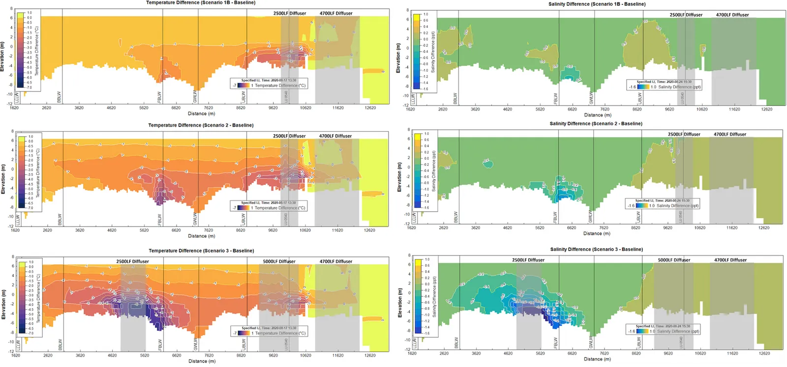 Temperature and salinity difference vertical profiles between the base model and the scenario runs along an extraction line from downstream of Shilshole Bay to Lake Washington
DSI calibrated their Lake Washington Ship Canal model for years 2018–2021 then applied its three-year calibrated EFDC+ hydrodynamic and salinity model of Lake Washington, Lake Union, and the Lake Washington Ship Canal (LWSC) to evaluate cold-water supplementation introduced at the Montlake Cut and transported downstream through the system. Model performance was verified for the period January 2018 through January 2021, demonstrating accurate simulation of water surface elevation, temperature, and salinity. Scenarios 1B, 2, and 3 were developed to represent increasing levels of pumped cold-water discharge. Model results were evaluated using temporal and spatial temperature distributions to assess thermal response in the canal. All scenarios were successfully implemented and produced measurable cooling, with summer temperature reductions exceeding 2°C near the diffusers and greater reductions under higher pumping rates (Scenarios 2 and 3). Additional temperature benefits were observed due to mitigation of salt wedge intrusion.
The final model results were submitted to the client to be used in developing and evaluating additional management scenarios.